Travels & Tours
Pictures, Photos, Images, & Reviews.
George & Eve DeLange.

Google Map To The Alyeska Pipeline Visitor Center.


View Larger Map
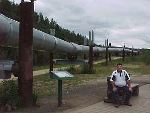
The Trans-Alaska Oil Pipeline. When oil was discovered in the North Slope area of the Brooks Range in Alaska in1968 it was decided that the only way the crude could be transported was overland via a pipeline. The pipeline is approximately 800 miles long crossing 3 mountain ranges(Brooks, Alaska, and Chugach Ranges) and 34 rivers and streams including the Yukon, Tanana, and the Chena Rivers . It runs from Prudhoe Bay on the Arctic Ocean to Valdez in the Pacific Ocean. Valdez was chosen because it was the nearest port that does not Ice over in the winter nearest port that does not Ice over in the winter. There were originally 12 pump stations along the line but it was discovered that the pipeline could be ran as efficiently with only 8. The rest are on either standby in case one fails, or in the case of pump station #5, it is left online to "pick up the slack"of the rest. The pipe used in the pipeline is 48 inches in diameter with a thickness between .462 and .562 inches and 40 in length(1) weighing 1400 pounds per length.(2). Each welded joint in the pipe was x-ray inspected and pressure tested to insure that the pipe line could hold up to the oil being pumped through it. The pipeline took 3 years and over 8 Billion dollars to complete. The project used 126 shiploads of pipe and employed over two thousand contractors and subcontractors. Before one section of pipe was laid in the actual line, there was $2.2 million put into research to design the support system and insulation system. The support structure had to withstand enormous stresses these stresses included the stresses of seismic activity, to the simple stress of the tundra melting and freezing. The engineers had to account for the expansion and contraction of the pipe and supports as the temperature changes. "Each 40 ft. length of pipe expands .031 inches with each 10� F rise in temperature and contracts the same distance with each 10� F drop in temperature." This produces about 9 inches longitudinally. Multiplied by thousands of pieces of pipe that is a lot of expansion. The engineers addressed this problem by placing the pipe in a zigzag formation. The engineers addressed the problem of seismic activity and ground thawing by designing special supports, consisting of two vertical supports with a horizontal cross member and a shoe that is connected to the pipe. The vertical supports are driven approximately 15 feet into the permafrost to anchor them. Since the permafrost never thaws it is as stable as rock. In areas that it was unsuitable to suspend the pipe, such as when the pipeline crossed roads. Engineers had to design special trenches and bedding to keep the oil from leaking. Most ditches were between 8and 16 feet deep, but in one particular the ditch had to be dug approximately 50 feet deep. Zinc ribbons were buried alongside the pipe to act as sacrificial anodes to prevent corrosion to the oil carrying pipes. In areas where the soil was unstable or to avoid rockslides and avalanches the pipe was buried in an insulated jacket. In areas that the pipe had to be buried the engineers designed special cooling systems that circulated chilled brine around the pipeline to keep the permafrost from thawing. Engineers also had to design ways to cross rivers and streams. They accomplished this in a number of ways. In small streams they simply buried the pipeline. In larger streams they encased each section of pipe in 75,000 pounds of concrete. Where larger rivers were concerned they had to build a bridge to get the pipe across. There are 13 bridges in the pipeline. Heading out of Fairbanks towards Fox, there is a park called The Alyeska Pipeline Visitor Center, less than 10 miles from downtown Fairbanks. You can actually walk up to the Pipeline and touch it. We Did!
|
The Ted Stevens Anchorage International Airport (IATA: ANC, ICAO: PANC, FAA LID: ANC)[2] is the major airport in the state of Alaska located 4 nautical miles (7 km) southwest of downtown Anchorage. Fairbanks and Juneau are the next busiest airports. Anchorage traffic peaks during June, July and August when passenger numbers are twice as high as between October and April. Some of the most popular destinations in Alaska are: Anchorage, Denali Park, Fairbanks, Seward, and Talkeetna. We have placed links to Priceline.com on this page so you can arrange your flights into and out of the various places in Alaska; as well as hotels, and rental 4 wheel drive vehicles; when visiting this beautiful State. Priceline.com can also arrange very nice Alaska Cruises; which we highly recommend. Cruises are usually taken during the warm late spring through early fall seasons, due to the freezing temperatures of the winter.
|
 |  |
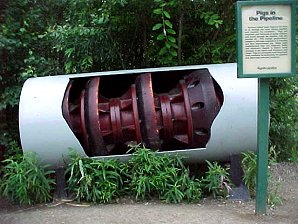
| The Alaska Pipe Line | A Device Called A Pig Used To Clean The Pipe Line |
|---|---|
 |  |
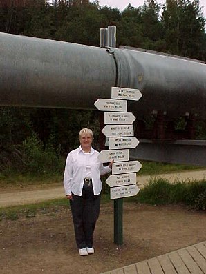
| George Under The Pipe | Audrey DeLange "Where Shall We Go Now?" |
We Are Proud Of Our SafeSurf Rating!
Click On Any Of The Following Links By Amazon.Com
For Books, & Videos About Touring Alaska. No Obligation!
Click On Any Of The Following Links By Amazon.Com
For Books, & Videos About Touring Alaska. No Obligation!
| Back To Alaska Tour Index Page
|
| Back To DeLange Home Page
Images And Text Copyright George & Eve DeLange
|


