Chaco Culture National Historical Park.
Northwestern New Mexico,
Between Albuquerque & Farmington.
Hikes, Travels, & Tours
Pictures, Photos, Images, & Reviews.
October 07, 2011

October 07, 2011

Click On Any Of The Following Links By Amazon.Com
For Books Or Videos About The Chaco Culture National Historical Park, NM. No Obligation!


Chaco Canyon Chetro Ketl Great kiva Plaza.
Chaco Culture National Historical Park. New Mexico.
Courtesy: Wikipedia, the free encyclopedia.
Google Map To Chaco Culture National Historical Park Visitor Center, New Mexico.
View Larger Map

Chaco Culture National Historical Park:
We wish to thank Wikipedia, the free encyclopedia for some of the images and information on this page. We share information with Wikipedia.
The Chaco Culture National Historical Park is a United States National Historical Park hosting the densest and most exceptional concentration of pueblos in the American Southwest.
The Chaco Culture National Historical Park preserves one of the United States' most important precolumbian cultural and historic areas containing the largest collection of ancient ruins north of Mexico
The park is located in northwestern New Mexico, between Albuquerque and Farmington, in a remote canyon cut by the Chaco Wash.
Between about AD 900 to AD 1150, Chaco Canyon was perhaps the major center of culture for the Ancient Pueblo Peoples.
The Chacoans quarried sandstone blocks and hauled timber from great distances, assembling 15 major complexes which remained the largest buildings in North America until the 19th century.
The author of this web page, George DeLange has studied archaeoastronomy for many years and is aware that evidence of archaeoastronomy at Chaco has been proposed, with the Sun Dagger petroglyph at Fajada Butte being a popular example.
Many Chacoan buildings may have been aligned to capture the solar and lunar cycles, requiring generations of astronomical observations and centuries of skillfully coordinated construction.
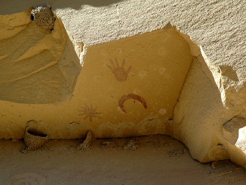
The Chaco Canyon Pueblo Bonito Petroglyphs shown on this web page is thought to depict the explosion of a giant star called the "Supernova 1054 AD."
In fact George DeLange has discovered another site in Central Arizona that is thought to show the same event of the exploding star. Here is a link to that web site. Supernova Of 1054 AD - The Crab Nebula - M1
A gradual, normal, change of climate, in the southwest United States is thought to have led to the emigration of the Chacoans, and of other Native Americans of the southwest from their homes; and the eventual abandonment of the Chaco Canyon, beginning with a 50-year drought in about AD. 1130.
Chaco Canyon lies within the San Juan Basin, atop the vast Colorado Plateau, surrounded by the Chuska Mountains in the west, the San Juan Mountains to the north, and the San Pedro Mountains in the east.
The canyon itself, located within lowlands circumscribed by dune fields, ridges, and mountains, runs in a roughly northwest-to-southeast direction and is rimmed by flat massifs known as mesas.
Large gaps between the southwestern cliff faces�side canyons known as rincons�were critical in funneling rain-bearing storms into the canyon and boosting local precipitation levels.
The alluvial canyon floor slopes downward to the northeast at a gentle grade of about 30 feet per mile; it is also bisected by the Chaco Wash, an arroyo that rarely bears water.
Of the canyon's aquifers, the largest are located at a depth that precluded ancient Chacoans from drawing groundwater: only several smaller, shallower sources supported the small springs that sustained them.
Aside from occasional storm runoff coursing through arroyos, significant surface water is virtually non-existent.
The ancient Chacoans drew upon dense forests of oak, pi�on, ponderosa pine, and juniper to obtain timber and other resources.
Chaco Canyon is now a UNESCO World Heritage Site and due to the danger of erosion which could be caused by tourists the Fajada Butte is closed to the public.
The sites in Chaco Culture National Historical Park are considered sacred ancestral homelands by the Hopi and Pueblo people, who maintain oral accounts of their historical migration from Chaco and their spiritual relationship to the land.
Though park preservation efforts can conflict with native religious beliefs, tribal representatives work closely with the National Park Service to share their knowledge and respect the heritage of the Chacoan culture.
The principal Chacoan complexes in the park, such as Pueblo Bonito, Nuevo Alto, and Kin Kletso, have elevations of 6,200 to 6,440 feet.
History Of The Chaco Culture People:
Archaeologists Say The Following:
The first people in the San Juan Basin were hunter-gatherers: the Archaic. These small bands descended from nomadic Clovis big-game hunters who arrived in the Southwest in about 10,000 BC.
By about 900 BC, Archaic people lived at Atlatl Cave and similar sites. They left little evidence of their presence in Chaco Canyon. By about AD 490, their descendants, called the Basketmakers by archaeologists, farmed lands around Shabik'eshchee Village and other pithouse settlements at Chaco.
A small population of Basketmakers remained in the Chaco Canyon area. The broad arc of their cultural elaboration culminated around AD 800, when they were building crescent-shaped stone complexes, each comprising four to five residential suites abutting subterranean kivas, large enclosed areas reserved for rites. Such structures characterize the Early Pueblo People. By about AD 850, the Ancient Pueblo population�the "Anasazi", from a Ute term adopted by the Navajo denoting the "ancient ones" or "enemy ancestors"�had rapidly expanded: groups resided in larger, denser pueblos. Strong evidence attests to a canyon-wide turquoise processing and trading industry dating from the 10th century. Around then, the first section of Pueblo Bonito was built: a curved row of 50 rooms near its present north wall.
Pueblo Bonito, largest of the Great Houses, abuts the foot of Chaco Canyon's northern rim. The cohesive Chacoan system began unravelling in about AD 1140, perhaps triggered by an extreme 50-year drought that began in about AD 1130. This chronic climatic instability, including a series of severe droughts, again struck the region between about AD 1250 to AD 1450. Other factors began to influence their society, included water management patterns (leading to arroyo cutting) and deforestation. (For instance, timber for construction was imported from outlying mountain ranges, such as the Chuska Mountains over 50 miles to the west.) This all began to cause outlying communities to disappear and, by the end of the century, the buildings in the central canyon had been carefully sealed and abandoned.
Some scholars suggest that violence and warfare, perhaps involving cannibalism, impelled the evacuations. Hints of violence, warfare, & cannibalism include dismembered bodies�dating from Chacoan times�found at two sites within the central canyon. Yet the Chacoan complexes showed little evidence of being defended or defensively sited high on cliff faces or atop mesas, and only several minor sites at Chaco evidence the large-scale burning that would suggest enemy raids. Archaeological and cultural evidence leads scientists to believe people from this region migrated south, east, and west into the valleys and drainages of the Little Colorado River, the Rio Puerco, and the Rio Grande.
You can read more from the anthropologist Joseph Tainter, who deals at length, with the structure and decline of Chaco civilization in his 1988 study The Collapse of Complex Societies.
Park Open Every Day Year Round 7:00 a.m. to sunset. On Holidays, the park's roads, sites, trails and campground will remain open.
Visitor Center is open from 8:00 a.m. to 5:00 p.m.
Phone: (505) 786-7014 ext. 221
Visitor Center is closed on Thanksgiving, Christmas Day, and New Year's Day
We suggest that visitors first stop at the visitor center to receive brochures, trail maps, and current park information.
Closed: Thanksgiving, Christmas, and New Year's days. Also closed during severe weather. The visitor center typically closes at 2:00 p.m. on Thanksgiving, Christmas, and New Year's eve's.
We suggest checking for more information, that is constantly updated, at the Chaco Culture National Historical Park link, at the bottom of this page.
How To Get There:
For a Chaco Culture National Historical Park Road Area Map, of the roads surrounding the park, in Acrobat pdf format click "Chaco Culture National Historical Park Road Area Map".
For a Chaco Culture National Historical Park Map, of park site locations, in Acrobat pdf format click "Chaco Culture National Historical Park Site Map".
The Chaco Culture National Historical Park's visitor center is located on the northwestern part of New Mexico. The preferred and recommended access route to the park is from the north, via US 550 (formerly NM 44) and County Road (CR) 7900, and CR 7950.
There are other routes, we have been on some of them, but WE DO NOT RECOMMEND THEM! We won't even mention them!
Warning: Some of the local roads recommended by map publishers and services using GPS devised to access Chaco are also unsafe for passenger cars. Please use our written directions below to avoid getting lost or stuck! These are also written directions recommended by the Chaco Culture National Historical Park!
From the north, turn off US 550 at CR 7900--3 miles southeast of Nageezi and approximately 50 miles west of Cuba (at mile 112.5). This route is clearly signed from US 550 to the park boundary (21 miles). The route includes 8 miles of paved road (CR 7900) and 13 miles of rough dirt road (CR7950).
If you are planning to visit Chaco Culture National Historical Park, New Mexico. And if you are coming from outside of New Mexico, you could fly into nearest major airport to Albuquerque, New Mexico; which is Albuquerque International Sunport (IATA: ABQ, ICAO: KABQ, FAA LID: ABQ) is a public airport located 3 miles southeast of the central business district of Albuquerque, a city in Bernalillo County, New Mexico, United States.
It is the largest commercial airport in the state. The airport serves Albuquerque and Santa Fe, providing regional jet service to Dallas-Fort Worth International Airport and Los Angeles International Airport), and then rent a car.
There are many hotels and motels in New Mexico and Colorado, and if you need a place to stay; Priceline.com can arrange that for you.
We have personally, booked flights, hotels, and vacations; through Priceline.com and we can highly recommend them. Their website is also easy to use!
We have some links to Priceline.com on this page since they can arrange all of your air flights, hotels and car.
We of course, appreciate your use of the advertising on our pages, since it helps us to keep our pages active.
Whenever you make a purchase from a link on our page we get credit for that transaction. Again, Thanks!


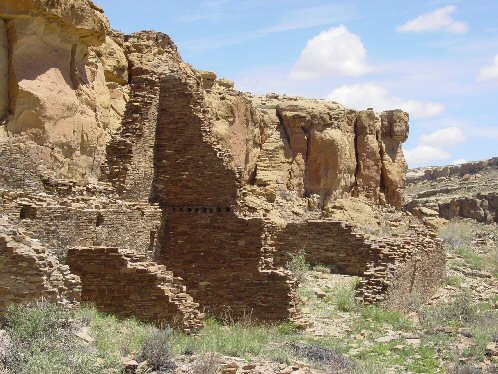
Chaco Canyon Hungo Pavi Ruins Staircase.
Chaco Culture National Historical Park.
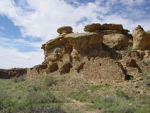
Courtesy: NPS. Casa Chiquita.
Chaco Culture National Historical Park.
Courtesy: NPS. 

Chaco Canyon Pueblo Bonito Petroglyphs Supernova 1054 AD.
Chaco Culture National Historical Park.
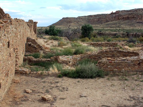
Courtesy: Wikipedia, the free encyclopedia. Casa Rinconada.
Chaco Culture National Historical Park.
Courtesy: Wikipedia, the free encyclopedia.
Click On Any Of The Following Links By Amazon.Com
For Books Or Videos About The Chaco Culture National Historical Park, NM. No Obligation!

We Are Proud Of Our SafeSurf Rating!

Send E-Mail to: George DeLange: [email protected]

Back To New Mexico & Colorado Tours Page
Back To DeLange Home Page
Link To Chaco Culture National Historical Park, New Mexico Home Page
You Will Leave deLange.org


 |
| Chaco Canyon Chetro Ketl Great kiva Plaza. Chaco Culture National Historical Park. New Mexico. Courtesy: Wikipedia, the free encyclopedia. |
|---|
Google Map To Chaco Culture National Historical Park Visitor Center, New Mexico.
View Larger Map

Chaco Culture National Historical Park:
We wish to thank Wikipedia, the free encyclopedia for some of the images and information on this page. We share information with Wikipedia.
The Chaco Culture National Historical Park is a United States National Historical Park hosting the densest and most exceptional concentration of pueblos in the American Southwest. The Chaco Culture National Historical Park preserves one of the United States' most important precolumbian cultural and historic areas containing the largest collection of ancient ruins north of Mexico The park is located in northwestern New Mexico, between Albuquerque and Farmington, in a remote canyon cut by the Chaco Wash. Between about AD 900 to AD 1150, Chaco Canyon was perhaps the major center of culture for the Ancient Pueblo Peoples. The Chacoans quarried sandstone blocks and hauled timber from great distances, assembling 15 major complexes which remained the largest buildings in North America until the 19th century. The author of this web page, George DeLange has studied archaeoastronomy for many years and is aware that evidence of archaeoastronomy at Chaco has been proposed, with the Sun Dagger petroglyph at Fajada Butte being a popular example. Many Chacoan buildings may have been aligned to capture the solar and lunar cycles, requiring generations of astronomical observations and centuries of skillfully coordinated construction. The Chaco Canyon Pueblo Bonito Petroglyphs shown on this web page is thought to depict the explosion of a giant star called the "Supernova 1054 AD." In fact George DeLange has discovered another site in Central Arizona that is thought to show the same event of the exploding star. Here is a link to that web site. Supernova Of 1054 AD - The Crab Nebula - M1 A gradual, normal, change of climate, in the southwest United States is thought to have led to the emigration of the Chacoans, and of other Native Americans of the southwest from their homes; and the eventual abandonment of the Chaco Canyon, beginning with a 50-year drought in about AD. 1130. Chaco Canyon lies within the San Juan Basin, atop the vast Colorado Plateau, surrounded by the Chuska Mountains in the west, the San Juan Mountains to the north, and the San Pedro Mountains in the east. The canyon itself, located within lowlands circumscribed by dune fields, ridges, and mountains, runs in a roughly northwest-to-southeast direction and is rimmed by flat massifs known as mesas. Large gaps between the southwestern cliff faces�side canyons known as rincons�were critical in funneling rain-bearing storms into the canyon and boosting local precipitation levels. The alluvial canyon floor slopes downward to the northeast at a gentle grade of about 30 feet per mile; it is also bisected by the Chaco Wash, an arroyo that rarely bears water. Of the canyon's aquifers, the largest are located at a depth that precluded ancient Chacoans from drawing groundwater: only several smaller, shallower sources supported the small springs that sustained them. Aside from occasional storm runoff coursing through arroyos, significant surface water is virtually non-existent. The ancient Chacoans drew upon dense forests of oak, pi�on, ponderosa pine, and juniper to obtain timber and other resources. Chaco Canyon is now a UNESCO World Heritage Site and due to the danger of erosion which could be caused by tourists the Fajada Butte is closed to the public. The sites in Chaco Culture National Historical Park are considered sacred ancestral homelands by the Hopi and Pueblo people, who maintain oral accounts of their historical migration from Chaco and their spiritual relationship to the land. Though park preservation efforts can conflict with native religious beliefs, tribal representatives work closely with the National Park Service to share their knowledge and respect the heritage of the Chacoan culture. The principal Chacoan complexes in the park, such as Pueblo Bonito, Nuevo Alto, and Kin Kletso, have elevations of 6,200 to 6,440 feet.
History Of The Chaco Culture People: Archaeologists Say The Following:
By about 900 BC, Archaic people lived at Atlatl Cave and similar sites. They left little evidence of their presence in Chaco Canyon. By about AD 490, their descendants, called the Basketmakers by archaeologists, farmed lands around Shabik'eshchee Village and other pithouse settlements at Chaco. A small population of Basketmakers remained in the Chaco Canyon area. The broad arc of their cultural elaboration culminated around AD 800, when they were building crescent-shaped stone complexes, each comprising four to five residential suites abutting subterranean kivas, large enclosed areas reserved for rites. Such structures characterize the Early Pueblo People. By about AD 850, the Ancient Pueblo population�the "Anasazi", from a Ute term adopted by the Navajo denoting the "ancient ones" or "enemy ancestors"�had rapidly expanded: groups resided in larger, denser pueblos. Strong evidence attests to a canyon-wide turquoise processing and trading industry dating from the 10th century. Around then, the first section of Pueblo Bonito was built: a curved row of 50 rooms near its present north wall. Pueblo Bonito, largest of the Great Houses, abuts the foot of Chaco Canyon's northern rim. The cohesive Chacoan system began unravelling in about AD 1140, perhaps triggered by an extreme 50-year drought that began in about AD 1130. This chronic climatic instability, including a series of severe droughts, again struck the region between about AD 1250 to AD 1450. Other factors began to influence their society, included water management patterns (leading to arroyo cutting) and deforestation. (For instance, timber for construction was imported from outlying mountain ranges, such as the Chuska Mountains over 50 miles to the west.) This all began to cause outlying communities to disappear and, by the end of the century, the buildings in the central canyon had been carefully sealed and abandoned. Some scholars suggest that violence and warfare, perhaps involving cannibalism, impelled the evacuations. Hints of violence, warfare, & cannibalism include dismembered bodies�dating from Chacoan times�found at two sites within the central canyon. Yet the Chacoan complexes showed little evidence of being defended or defensively sited high on cliff faces or atop mesas, and only several minor sites at Chaco evidence the large-scale burning that would suggest enemy raids. Archaeological and cultural evidence leads scientists to believe people from this region migrated south, east, and west into the valleys and drainages of the Little Colorado River, the Rio Puerco, and the Rio Grande. You can read more from the anthropologist Joseph Tainter, who deals at length, with the structure and decline of Chaco civilization in his 1988 study The Collapse of Complex Societies.
Park Open Every Day Year Round 7:00 a.m. to sunset. On Holidays, the park's roads, sites, trails and campground will remain open. Visitor Center is open from 8:00 a.m. to 5:00 p.m. Phone: (505) 786-7014 ext. 221 Visitor Center is closed on Thanksgiving, Christmas Day, and New Year's Day We suggest that visitors first stop at the visitor center to receive brochures, trail maps, and current park information. Closed: Thanksgiving, Christmas, and New Year's days. Also closed during severe weather. The visitor center typically closes at 2:00 p.m. on Thanksgiving, Christmas, and New Year's eve's.
We suggest checking for more information, that is constantly updated, at the Chaco Culture National Historical Park link, at the bottom of this page.
For a Chaco Culture National Historical Park Map, of park site locations, in Acrobat pdf format click "Chaco Culture National Historical Park Site Map".
The Chaco Culture National Historical Park's visitor center is located on the northwestern part of New Mexico. The preferred and recommended access route to the park is from the north, via US 550 (formerly NM 44) and County Road (CR) 7900, and CR 7950. There are other routes, we have been on some of them, but WE DO NOT RECOMMEND THEM! We won't even mention them! Warning: Some of the local roads recommended by map publishers and services using GPS devised to access Chaco are also unsafe for passenger cars. Please use our written directions below to avoid getting lost or stuck! These are also written directions recommended by the Chaco Culture National Historical Park! From the north, turn off US 550 at CR 7900--3 miles southeast of Nageezi and approximately 50 miles west of Cuba (at mile 112.5). This route is clearly signed from US 550 to the park boundary (21 miles). The route includes 8 miles of paved road (CR 7900) and 13 miles of rough dirt road (CR7950).
|
If you are planning to visit Chaco Culture National Historical Park, New Mexico. And if you are coming from outside of New Mexico, you could fly into nearest major airport to Albuquerque, New Mexico; which is Albuquerque International Sunport (IATA: ABQ, ICAO: KABQ, FAA LID: ABQ) is a public airport located 3 miles southeast of the central business district of Albuquerque, a city in Bernalillo County, New Mexico, United States. It is the largest commercial airport in the state. The airport serves Albuquerque and Santa Fe, providing regional jet service to Dallas-Fort Worth International Airport and Los Angeles International Airport), and then rent a car.
There are many hotels and motels in New Mexico and Colorado, and if you need a place to stay; Priceline.com can arrange that for you. We have personally, booked flights, hotels, and vacations; through Priceline.com and we can highly recommend them. Their website is also easy to use! We have some links to Priceline.com on this page since they can arrange all of your air flights, hotels and car. We of course, appreciate your use of the advertising on our pages, since it helps us to keep our pages active. Whenever you make a purchase from a link on our page we get credit for that transaction. Again, Thanks!
|
 |  |
| Chaco Canyon Hungo Pavi Ruins Staircase. Chaco Culture National Historical Park. Courtesy: NPS. | Casa Chiquita. Chaco Culture National Historical Park. Courtesy: NPS. |
|---|---|
 |  |
| Chaco Canyon Pueblo Bonito Petroglyphs Supernova 1054 AD. Chaco Culture National Historical Park. Courtesy: Wikipedia, the free encyclopedia. | Casa Rinconada. Chaco Culture National Historical Park. Courtesy: Wikipedia, the free encyclopedia. |
Click On Any Of The Following Links By Amazon.Com
For Books Or Videos About The Chaco Culture National Historical Park, NM. No Obligation!

We Are Proud Of Our SafeSurf Rating!


| Back To New Mexico & Colorado Tours Page
|
| Back To DeLange Home Page
|
| Link To Chaco Culture National Historical Park, New Mexico Home Page You Will Leave deLange.org
|


