
 |
| Click On This Photo For Professional High Quality Peru Tours From Magical Cusco Tours Just Mention delange.org With Code Inka2010 Get A 4% Tour Discount With Any Package Tour Purchase! |
|---|
Photos, Pictures, Images,
Descriptions, Information, & Reviews.
From Arequipa
To Colca Canyon
Then To The "Crux del Condor"
Lookout Point
Google Map To Village Of Cañahuas, Peru
View Larger Map
Google Map To Pampa Canahuas, A Reserve For Vicuñas, Peru
View Larger Map
Google Map To The Pass Of Patapampa, Peru
View Larger Map
Google Map To Chivay Town, Peru
View Larger Map
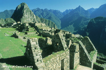
The Colca Canyon, one of the deepest canyons in the world, is said to be twice the depth of Arizonas Grand Canyon; but having lived in Arizona and hiked into the Grand Canyon, we would not agree with that statement. Even though the "canyon" is very deep; I would say that the Colca "Canyon" is not so much a traditional canyon as it is a deep river basin. Of course, each "canyon" has it's own unique beauty! The Colca Valley is extremely deep and picturesque. It is formed by the Colca River; surrounded by huge mountains, small villages, interesting market places, colonial churches, and green agricultural terraces hugging the hillsides with herds of wandering llamas. The Colca Valley is 124 miles long and 11,155 feet deep. It's Colca River is a popular "White Water" rafting spot with a world wide reputation. Because the valley is very deep, the rising winds are strong and the condors in the area, take advantage of these winds to soar gracefully into the sky. Located between Maca and Cabanaconde, where the winds are even stronger, is the "Cruz del Condor" lookout point. It is the most popular viewing point from which to see the Colca Valley and it is also a good place to see the giant condors soaring on their incredible wingspans above the depths of the canyon below. The main towns are Chivay, Cabanaconde, Huambo, Maca, Achoma, Yunque, Larl and Coporaque. Each town has a beautiful stone church and central plaza with a rectangular street plan of adobe houses sited on a natural river terrace. These major terraces have been further terraced for agriculture, producing maize and potatoes dating back to pre-Inca times. In fact the area has been inhabited by man for over 7000 years. In addition to being the first village on the edge of the canyon, Chivay is also the major point linking the two sides. Many people stay overnight in Chivay Town, located about three hours from Arequipa, and just a a little over an hour from the "Crux del Condor" lookout. On the opposite side of the bridge is the old Inca road to Cusco, which is marked by a path that heads up to ancient stone grain stores. Youll also find several Inca storehouses on the hillside above the trail. If youre up for a walk, head to Chivays 18th century church Nuestra Señora Asunción, or to the bridge with Inca foundations, which is located just outside of town. Because of the volcanic nature of the region, there are hot springs in many different areas of the valley. The main ones are Chivay, Yunque, Callalli, La Calera, Huancarama, Yura and Jesus. Furthermore, these hot springs are frequently related to 'puquiales", natural sources of cold, extremely pure and 100% potable water. La Calera hot springs at Chivay a wonderful way to relax after a day's touring. The Colca Valley's spectacular terracing is considered among the most extensive in southern Peru. These terraces, which allow cultivation and irrigation of the steep slopes of the canyon, were built by the Collagua and Cabana ethnic groups between the ninth and fourteenth centuries AD. The Collaguas occupied the eastern and central parts of the valley and the Cabanas settled in the lower part of the Colca Valley. Today the inhabitants of the Colca Valley still use some of the terraces for cultivation of corn, potatoes, broad beans, alfalfa, quinua, barley and wheat. While the Colca Canyon two day or longer tour was very nice, we would recommend that the direct trip, which leaves Arequipa at 3 AM in the morning and gets back at about 6 PM, would be a much better choice if you only have a short time to stay in Peru. We would especially make this recommendation if you are experiencing any altitude sickness. We used the city of Arequipa as our base while preparing to visit Colca Canyon. Arequipa is well known for its glistening white buildings made from sillar, a white volcanic rock, which gives the city its nickname 'La Ciudad Blanca' or 'The White City'. Arequipa is Peru's second largest city and was founded in 1540. The site was chosen for its proximity to the coast, enabling settlers to trade the products of Cusco and the mines of Potosi (Bolivia) with Lima. The local cultivation of wheat, corn and grapes all contributed to the regions economic growth. Arequipa is surrounded by three volcanoes; El Misti, still active at 19,100.82 feet, the higher and extinct Chachani 19,930.86 feet and Pichu Pichu 18,277.34 feet. The melt water from the snow-capped peaks of these volcanoes form the headwaters of the mighty Amazon River, thousands of kilometers away. We visited Colca Canyon on April 23, 2006 through April 24, 2006. We left from the Libertador Hotel In Arequipa Peru on April 23, 2006 At 8:00 AM. We returned at about 6:00 PM on April 24, 2006. Leaving Arequipa, we headed northeast of the city towards Yura, past El Misti Volcano, climbing behind Mt. Chachani into the high altitude desert savannah - known as puna - crossing Pampa Cañahuas, a chance to see vicuñas and views of the volcano of Sabancaya and the snow-capped peaks above the Colca Valley passing by the village of Chivay. The peaks are 15747.84 feet tall. We then stopped at the Pass Of Patapampa between Arequipa and Chivay is at an altitude of 15911.88 feet to admire the distant volcanoes amidst an area strewn with little stone prayer cairns built by the native travelers over the pass. The road then zigzags down to the village of Chivay, the biggest of about 14 villages in the Colca Valley established by the Viceroy Toledo in the 16th century, who insisted that the rural converted Indians live close together. There we have lunch and then are driven to our hotel for the evening, the Colca Canyon Lodge. At around 7:00 AM the next morning we head towards the Cruz del Condor vantage point, a spot from where you have an extremely good view on the and from where you can observe best the spectacular flight of the condors. On the way we stop at the Mirador de Choquetico vantage point to see a a Shrine to Apu, the mountain god. The Inca believed that, by terracing, they were affecting the body of Apu, the mountain god. They would commonly carve the plans for the terracing on the mountain wall, seeking Apu's approval and a bountiful harvest. Also at Mirador de Choquetico we saw the fantastic hanging tombs or in Spanish "tumbas colgantes"; which resulted in the Colca Valley's name. We then stopped at the Cruz del Condor vantage point for about two hours to see some wonderful views of Colca Canyon and the famous Peruvian "Andean Condors" that frequent the area. After viewing the condors, we returned back the way we had come to the Mirador de Antahuilque vantage point to view the Colca Valley Terraces and three mysterious lagoons.
|
The Rodríguez Ballón International Airport (IATA: AQP, ICAO: SPQU), known as Aeropuerto Internacional Rodríguez Ballón in Spanish, is the airport serving Peru's second largest city, Arequipa. This airport and Cusco's Alejandro Velasco Astete International Airport are the two main air hubs in southern Peru. Its runway is fully paved. It is the main air entrance for tourists visiting the city of Arequipa, the spectacular nearby ruins, and the Colca Canyon, the world's second deepest canyon (only behind Cotahuasi Canyon, also located in Arequipa.) Arequipa's airport is served by Lan Peru airlines, Taca Air, and Aero Condor. It's only an hour to or from Lima and just a little over a half hour to or from Cusco. A taxi to the city center from the airport should cost only about 10 Soles, so if the driver is trying to charge you significantly more than that, it's probably because you're a Gringo! Some people question the depth of the world's deepest canyons so here are the official depths and world rankings: A. Yarlung Tsangpo in China is 6,009 meters (19,715 feet) deep, B. Colca Canyon in Peru 3,501 meters (11,488 feet) deep, C. Cotahuasi Canyon in Peru 3,354 meters ( 11,001 feet) deep, & D. the Grand Canyon in USA is 1,737 meters (5,697 feet) deep. There are Guided Tour Agencies offering standard city, Hiking, and archaeological tours of the area. Most of the Arequipa tour companies are located on Jerusalén street, the Santa Catalina Convent area, and near the Plaza de Armas. They offer tours of Colca Canyon, Cotahuasi, Toro Muerto, and the city tours in Arequipa itself. This page is for information purposes only and while we have made every effort to be accurate, it is the travelers responsibility to make the appropriate choice as to which hotels to use in Peru. We found that when touring Peru, Magical Cusco Tours gave us the best service of all. They even arranged very personal tours based upon our ages and experience. They were there for us whenever we needed them. Click on any of their links on our pages and they will give you a 4% discount for taking their package tours. Mention delange.org. Merchant Code Inka2010 for your discount! We suggest letting Ana Maria handle your tour. Note: The 4% discount applies to package tours only! Discount does not apply to hotel bookings, domestic or international tickets, meals or any other service booked as a single activity.
Magical Cusco Tours also has a culinary tour that you may enjoy.Click Here For: Taste Of Peru.com their culinary tour page.
|

We're Glad You Stopped By! Come back soon!
 |
| Colca Canyon Area Map |
|---|
 |
| Colca Canyon Detail Map, Courtesy of Rumi Llaqta Hotel |
|---|
Click Here To See A Video Of A Very Funny Alpaca 7.86 MB File |
 |
| View Of Pampa Canahuas, A Reserve For Vicuñas |
|---|
 |
| The "Stone Forest Of Puruna. Next To The Village Of Cañahuas. " |
 |
| Weaving Woman At Canahuas Village Market. |
 |
| Patapampa Pass Prayer Rock Cairns. Peru Photos, Pictures, Information. |
 |
| Patapampa Pass Prayer Rock Cairns. Peru Photos, Pictures, Information. |
 |
| Llama Near Chivay Town. |
 |  |
| On April 23, 2006 At 8:00 AM We left The Libertador Hotel Ciudad Blanca In Arequipa Peru For Colca Canyon | We Stop In A Residencial Area To Pick Up Some Other People |
|---|---|
 |  |
| We Then Drive By Arequipa's Plaza de Armas | And "La Compañia de Jesus" Arequipa's Cathedral Founded 1612 |
 |  |
| Urban Areas Are Growing All Around Arequipa | Small Municipalities Are Springing Up Where There Was Nothing A Few Years Ago |
 |  |
| There Are Businesses And Schools Developing | Caused By The Population Movement Into The Cities From The Farms |
 | |
| We Pass A Cement Plant A Few Miles Outside Of Town | We Leave All Of This Behind As We Drive Higher In Altitude |
 |  |
| As We Climb Higher We See Many Volcanoes | Another Volcano |
 |  |
| We Are Now At The Famous Protected Reserve Pampa Canahuas | A Reserve For Vicuñas And Other Indigenous Species |
 |  |
| Vicunas | Vicuñas Mother & Baby |
 |  |
| Next To The Village Of Cañahuas | On The Banks Of The Sumbay River |
 |  |
| What Are These Strange Sandstone Formations | The "Stone Forest Of Puruna" |
 |  |
| Cañahuas Village Market | Canahuas Village Market El Misti Volcano In Background |
 |  |
| Canahuas Village Market | Canahuas Village Market |
 |  |
| Canahuas Village Market | Canahuas Village Market |
 |  |
| We Leave Canahuas Village | And See Alpoca On The Road |
 |  |
| A Little Further And We Drive Through The Pass Of Patapampa In Addition To Volcanos | We See Amazing Rock Cairns They Are Where Prayers Are Made By Travelers To The Area |
 |  |
| Patapampa Prayer Rock Cairns | Patapampa Prayer Rock Cairns |
 |  |
| This Llama Is Near The Drop Off Into Chivay Town | A View Of Chivay Town |
 |  |
| Our Chivay Town Resturant | Our Chivay Town Resturant |
 |  |
| Inside The Resturant | Good Food |
 |  |
| Chivay Town Street | Chivays 18th Century Church Nuestra Señora Asunción |
 |  |
| From Chivay Town We Are Headed For Colca Canyon Lodge | And A Good Meal! We Will See Condors Tomorrow! |
We Are Proud Of Our SafeSurf Rating!

Click On Any Of The Following Links By Amazon.Com
For Books About Hiking Or Touring In Peru.
Some Are Must Have Books - If You Are Going To Peru.
We Also Are Including Some Great Music CD's & DVD's. No Obligation!
Click Here To The Colca Canyon To Arequipa
(By Way Of The "Crux del Condor" Lookout Point) Page
Back To Peru Tours Main Page
Back To DeLange Home Page

(By Way Of The "Crux del Condor" Lookout Point) Page