
South of Merida Near Telchaquillo
On The Yucat�n Peninsula, Yucat�n, M�xico.
Travel & Tour
Pictures, Photos, Information, Images, & Reviews.
George & Eve DeLange
Google Map To The Mayapan Archaeological Ruins.
About 1 km From Telchaquillo, Yucatan, Mexico.

View Larger Map
Click On Any Of The Following Links By Amazon.Com
For Books Or Videos About The Mayan People In Mexico. No Obligation!
"The Caracol" Of Mayapan.
"El Castillo" Or "Kukulcan Temple" Of Mayapan.
|
| "The Caracol" Of Mayapan. |
|---|
|
| "El Castillo" Or "Kukulcan Temple" Of Mayapan. |
|---|
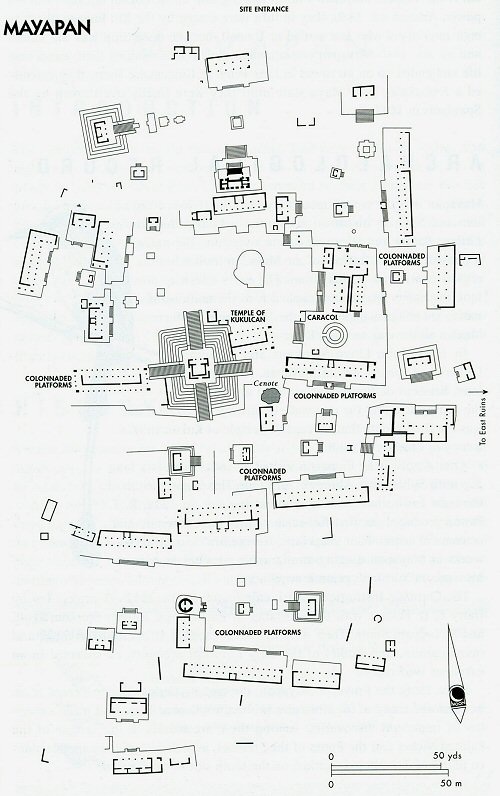 |
| Mayapan Site Map, Courtesy Andrew Coe's, "Archaeological Mexico." |
|---|
Click On Any Of The Following Links By Amazon.Com
For Books Or Videos About Touring The Yucat�n Peninsula In Mexico. No Obligation!
Mayapan (mah-yah-PAHN), located in the Yucatan in Southeastern Mexico, approximately 24 mi/39 km SSE of Merida. Our GPS marks Mayapan's entrance at about 20o 37' 57.11" N 89o 27' 30.47" W.
Our first impression of Mayapan is that it is a beautiful, uncrowded archaeological site and that it is a wonderful place to visit.
As we walked around the site we also noticed that some of the buildings resemble buildings at Chichen Itza. The obvious difference between Mayapan and Chichen Itza is that the buildings at Mayapan are not built as well as at Chichen Itza.
Even though they appear to be copies they are not built as sturdy and they are not finished off in such a way to be nearly as attractive as those at Chichen Itza. The lack of quality workmanship is very obvious.
Archaeologists say that one problem faced by the city's builders was that the stone in Mayapan's immediate vicinity is of poor quality. This may have caused the builders to scavenge their veneer from the neighboring settlements.
Another thought is that the rulers were more concerned with the widespread warfare going on in their area than in the building of temples.
The site is not well marked with signs describing the various structures and only the major structures are marked. Even so, the descriptions of the ones that are marked are very limited.
TOURING THE SITE
We entered the site of Mayapan from the North. We noticed that unexcavated mounds lie on either side of the road into the parking area.
Once we paid our fee at the small ticket station and entered the site from the parking lot we walked about seventy five meters South onto the ceremonial center of the site.
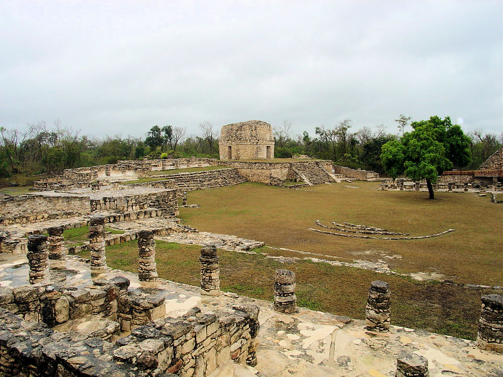
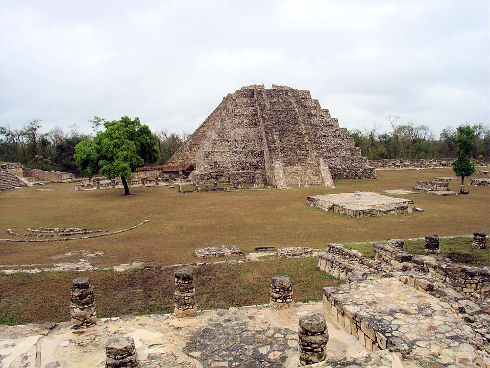
We first entered a small plaza; to the West we see a four-stage platform with a small temple on top. Two carved serpent columns guard its doorway. Next, we walked past some low colonnaded platforms to another plaza, at the South side of the plaza we see Mayapan's most famous structure, the nine-tiered "Temple of Kukulcan."
It is a smaller, version of the "Castillo" at Chichen Itza. The workmanship is very poor compared to Chichen Itza. We noticed that its staircases rise on all four sides of the pyramid to a square three-room temple on top, with two serpent columns facing north from the main doorway. From the temple, if we look South we see the Sierrita de Ticul-the hills which are located on the northern border of the Puuc region.
We had read that a carbon 14 test performed on a platform below its base established a date of 1015 A.D. for its construction.
We notice that the temple's angles are not well defined and that the staircases do not seem to be in the true center of each face of the platforms.
On the South side of the Castillo, there are roofs which cover stucco reliefs of decapitated warriors.
Walking to the East, we see that a platform holds the "Caracol" which is a spiral structure built around a solid core that appears to be a copy of Chichen Itza's observatory. Having studied astronomy for many years and the structure and alignments at the "Caracol", we beleive that the observational alignments at Mayapan are more obvious than at Chichen Itza.
Most of the other ceremonial center structures at mayapan seem to be long hallways faced with colonnades. Archaeologists think that these were used as council halls and as schools.
The site is easily accessible and open to the public. To get to Mayap�n from M�rida, the capital of Yucat�n, take either 63rd or 67th Street from the downtown area out to the M�rida highway (perif�rico). Then turn right onto the highway. Then turn left at the sign to Mayap�n. Go clear through the town of Kanasin and then take the two-lane highway south past Acanceh and Tecoh.
Less than one kilometer after passing the town of Telchaquillo, you will find the entrance to the site on your right. It is well-marked. The site is open every day. There is a small entrance fee. Most of the placemarks on the Google Maps are not correct. The map on our page shows the correct location of the ruins of Mayapan.
There is lots of parking and clean restrooms at the site, but there are no other facilities. Snacks and sodas are available at the stores in nearby Telchaquillo.
We were on the site February 7, 2004 at about 12:30 P.M. The rainy season is just starting, so the site was wet from an afternoon rain. It was actually cold when we were there and we needed to wear warm clothing! It continued to sprinkle when we were on site so it was a little difficult to take photos and to avoid getting the camera lens wet.
The Manuel Crescencio Rej�n International Airport, formerly known as M�rida-Rej�n Airport (IATA: MID, ICAO: MMMD) is the international airport located in the Mexican city of M�rida, Yucat�n. It is located on the southern edge of the city.
The airport handles both domestic and international flights, and is open 24 hours a day.
We suggest flying into M�rida and staying in one of their many fine hotels when touring Mayapan and the ruins in the surrounding area.
We have links on this page that will connect you with flights into M�rida and several of the best hotels in M�rida.
After getting a flight and a hotel we suggest asking your hotel concierge to arrange either a car or a tour of Mayapan or the M�rida area. If you call their Concierge Services ahead of your arrival, all of this can be pre-arranged for you.
We do this all the time, when traveling in Mexico. It is safe and it works!!! We have never experienced a problem, doing it this way!
Therefore, we have placed links to Priceline.com on this page so you can arrange your flights into and out of M�rida; as well as your hotel, when visiting this area.


Our First View Of Mayapan
About 35 Meters Onto The Site
Pictures Panned East To West Our First View Of Mayapan
About 35 Meters Onto The Site
Pictures Panned East To West 

Our First View Of Mayapan
About 35 Meters Onto The Site
Pictures Panned East To West About 70 Meters Onto The Site
Right After A Brief Rain
This Photo Shows Main Structures 
Columned Low Platform To West Small Pyramid Further West 

Another Small Pyramid And Temple
South Of Main Entrance "Kukulcan Temple" As Seen
From Top Of Small Temple 

Audrey DeLange
Entering Top Temple
Of The Small Temple Inside The Temple
Note The Arch 

Another Small Temple With
Thatch Roof, East Of
Where We Entered The Plaza Closer View Of Temple
We Will Go On Top 

Thatch Roof On Top Plaster Floor Protected By Roof 

"Caracol", "El Castillo,"
"Small Temple."
Seen From
Thatch Roof Temple.
Looking South Two Small Temples
& Platform
West Of Where
We Entered Site
Seen From
Thatch Roof Temple. 

"El Caracol", The Observatory
Photo From
West Of The "Cenote." George DeLange Inside
"El Caracol,"
The Observatory 

Inside "El Caracol."
Ceiling View Inside "El Caracol."
Ceiling View 
Inside "El Caracol."
Doorway View Inside "El Caracol."
Doorway View 

Doors Aligned
To Cardinal Directions
West View Doors Aligned
To Cardinal Directions
North View 

Doors Aligned
To Cardinal Directions
South View Doors Aligned
To Cardinal Directions
East View 

SW Side Of "El Caracol" Reliefs Close Up Of Relief 

Close Up Of Relief Chaac Mask Located On South
Side Of The Observatory 

Reliefs On South Side
Of Observatory Reliefs On South Side
Of Observatory 

Relief On South Side
Of Observatory Statues On East Side
Of Observatory 

Statues On East Side
Of Observatory Statues On East Side
Of Observatory 

The "Cenote."
Viewed From "Caracol."
Drain From Building
Just South
Drains Into The Cenote "Cenote" Close Up 

North Side Of "El Castillo" East Side Of "Kukulcan Temple" 

NNE Corner Decapitated Warrier
Stucco Reliefs ENE Corner Reliefs, It Is Thought
Decapitated Head
Was Placed In Niche 

Original Plaster On North Side
Of East Stairway Of "El Castillo" Freize On ESE Corner Of
"El Castillo" 

Freize On ESE Corner Of
"El Castillo" Freize On ESE Corner Of
"El Castillo" 

Serpant Head North Side Of
"El Carasol" Close Up Of Serpant Head 

Colonnaded Platform On North Small Temple On West
We Are Proud Of Our SafeSurf Rating!

Click On Any Of The Following Links By Amazon.Com
For Books Or Videos About Touring In Mexico. No Obligation!
Here Are Some Links To The Very Best & Most Popular Items Sold On Amazon.Com
To Learn More! Click The Links Below. No Obligation, Of Course!
Other Mexico Web Pages !
Mayapan (mah-yah-PAHN), located in the Yucatan in Southeastern Mexico, approximately 24 mi/39 km SSE of Merida. Our GPS marks Mayapan's entrance at about 20o 37' 57.11" N 89o 27' 30.47" W. Our first impression of Mayapan is that it is a beautiful, uncrowded archaeological site and that it is a wonderful place to visit. As we walked around the site we also noticed that some of the buildings resemble buildings at Chichen Itza. The obvious difference between Mayapan and Chichen Itza is that the buildings at Mayapan are not built as well as at Chichen Itza. Even though they appear to be copies they are not built as sturdy and they are not finished off in such a way to be nearly as attractive as those at Chichen Itza. The lack of quality workmanship is very obvious. Archaeologists say that one problem faced by the city's builders was that the stone in Mayapan's immediate vicinity is of poor quality. This may have caused the builders to scavenge their veneer from the neighboring settlements. Another thought is that the rulers were more concerned with the widespread warfare going on in their area than in the building of temples. The site is not well marked with signs describing the various structures and only the major structures are marked. Even so, the descriptions of the ones that are marked are very limited. TOURING THE SITE We entered the site of Mayapan from the North. We noticed that unexcavated mounds lie on either side of the road into the parking area. Once we paid our fee at the small ticket station and entered the site from the parking lot we walked about seventy five meters South onto the ceremonial center of the site. We first entered a small plaza; to the West we see a four-stage platform with a small temple on top. Two carved serpent columns guard its doorway. Next, we walked past some low colonnaded platforms to another plaza, at the South side of the plaza we see Mayapan's most famous structure, the nine-tiered "Temple of Kukulcan." It is a smaller, version of the "Castillo" at Chichen Itza. The workmanship is very poor compared to Chichen Itza. We noticed that its staircases rise on all four sides of the pyramid to a square three-room temple on top, with two serpent columns facing north from the main doorway. From the temple, if we look South we see the Sierrita de Ticul-the hills which are located on the northern border of the Puuc region. We had read that a carbon 14 test performed on a platform below its base established a date of 1015 A.D. for its construction. We notice that the temple's angles are not well defined and that the staircases do not seem to be in the true center of each face of the platforms. On the South side of the Castillo, there are roofs which cover stucco reliefs of decapitated warriors. Walking to the East, we see that a platform holds the "Caracol" which is a spiral structure built around a solid core that appears to be a copy of Chichen Itza's observatory. Having studied astronomy for many years and the structure and alignments at the "Caracol", we beleive that the observational alignments at Mayapan are more obvious than at Chichen Itza. Most of the other ceremonial center structures at mayapan seem to be long hallways faced with colonnades. Archaeologists think that these were used as council halls and as schools. The site is easily accessible and open to the public. To get to Mayap�n from M�rida, the capital of Yucat�n, take either 63rd or 67th Street from the downtown area out to the M�rida highway (perif�rico). Then turn right onto the highway. Then turn left at the sign to Mayap�n. Go clear through the town of Kanasin and then take the two-lane highway south past Acanceh and Tecoh. Less than one kilometer after passing the town of Telchaquillo, you will find the entrance to the site on your right. It is well-marked. The site is open every day. There is a small entrance fee. Most of the placemarks on the Google Maps are not correct. The map on our page shows the correct location of the ruins of Mayapan. There is lots of parking and clean restrooms at the site, but there are no other facilities. Snacks and sodas are available at the stores in nearby Telchaquillo. We were on the site February 7, 2004 at about 12:30 P.M. The rainy season is just starting, so the site was wet from an afternoon rain. It was actually cold when we were there and we needed to wear warm clothing! It continued to sprinkle when we were on site so it was a little difficult to take photos and to avoid getting the camera lens wet.
|
The Manuel Crescencio Rej�n International Airport, formerly known as M�rida-Rej�n Airport (IATA: MID, ICAO: MMMD) is the international airport located in the Mexican city of M�rida, Yucat�n. It is located on the southern edge of the city. The airport handles both domestic and international flights, and is open 24 hours a day. We suggest flying into M�rida and staying in one of their many fine hotels when touring Mayapan and the ruins in the surrounding area. We have links on this page that will connect you with flights into M�rida and several of the best hotels in M�rida. After getting a flight and a hotel we suggest asking your hotel concierge to arrange either a car or a tour of Mayapan or the M�rida area. If you call their Concierge Services ahead of your arrival, all of this can be pre-arranged for you. We do this all the time, when traveling in Mexico. It is safe and it works!!! We have never experienced a problem, doing it this way! Therefore, we have placed links to Priceline.com on this page so you can arrange your flights into and out of M�rida; as well as your hotel, when visiting this area.
|
| |
| Our First View Of Mayapan About 35 Meters Onto The Site Pictures Panned East To West | Our First View Of Mayapan About 35 Meters Onto The Site Pictures Panned East To West |
|---|---|
| |
| Our First View Of Mayapan About 35 Meters Onto The Site Pictures Panned East To West | About 70 Meters Onto The Site Right After A Brief Rain This Photo Shows Main Structures |
| |
| Columned Low Platform To West | Small Pyramid Further West |
| |
| Another Small Pyramid And Temple South Of Main Entrance | "Kukulcan Temple" As Seen From Top Of Small Temple |
| |
| Audrey DeLange Entering Top Temple Of The Small Temple | Inside The Temple Note The Arch |
| |
| Another Small Temple With Thatch Roof, East Of Where We Entered The Plaza | Closer View Of Temple We Will Go On Top |
| |
| Thatch Roof On Top | Plaster Floor Protected By Roof |
| |
| "Caracol", "El Castillo," "Small Temple." Seen From Thatch Roof Temple. Looking South | Two Small Temples & Platform West Of Where We Entered Site Seen From Thatch Roof Temple. |
| |
| "El Caracol", The Observatory Photo From West Of The "Cenote." | George DeLange Inside "El Caracol," The Observatory |
| |
| Inside "El Caracol." Ceiling View | Inside "El Caracol." Ceiling View |
| |
| Inside "El Caracol." Doorway View | Inside "El Caracol." Doorway View |
| |
| Doors Aligned To Cardinal Directions West View | Doors Aligned To Cardinal Directions North View |
| |
| Doors Aligned To Cardinal Directions South View | Doors Aligned To Cardinal Directions East View |
| |
| SW Side Of "El Caracol" Reliefs | Close Up Of Relief |
| |
| Close Up Of Relief | Chaac Mask Located On South Side Of The Observatory |
| |
| Reliefs On South Side Of Observatory | Reliefs On South Side Of Observatory |
| |
| Relief On South Side Of Observatory | Statues On East Side Of Observatory |
| |
| Statues On East Side Of Observatory | Statues On East Side Of Observatory |
| |
| The "Cenote." Viewed From "Caracol." Drain From Building Just South Drains Into The Cenote | "Cenote" Close Up |
| |
| North Side Of "El Castillo" | East Side Of "Kukulcan Temple" |
| |
| NNE Corner Decapitated Warrier Stucco Reliefs | ENE Corner Reliefs, It Is Thought Decapitated Head Was Placed In Niche |
| |
| Original Plaster On North Side Of East Stairway Of "El Castillo" | Freize On ESE Corner Of "El Castillo" |
| |
| Freize On ESE Corner Of "El Castillo" | Freize On ESE Corner Of "El Castillo" |
| |
| Serpant Head North Side Of "El Carasol" | Close Up Of Serpant Head |
| |
| Colonnaded Platform On North | Small Temple On West |
We Are Proud Of Our SafeSurf Rating!
Click On Any Of The Following Links By Amazon.Com
For Books Or Videos About Touring In Mexico. No Obligation!
Here Are Some Links To The Very Best & Most Popular Items Sold On Amazon.Com
To Learn More! Click The Links Below. No Obligation, Of Course!
Other Mexico Web Pages !
To Learn More! Click The Links Below. No Obligation, Of Course!
Other Mexico Web Pages !